社会民生
厄尔尼诺现象为智利创造了滑雪者的天堂——现在轮到内华达山脉和南落基山脉了。
中文译文
厄尔尼诺现象被誉为滑雪者的梦想,它为加利福尼亚的内华达山脉和南部落基山脉带来大量降雪。2026年11月中旬,太浩湖地区的滑雪场就已出现降雪现象,积雪厚度达数英尺,一些滑雪场甚至准备提前开放迎客。不过,厄尔尼诺现象带来的强降水也可能带来麻烦。
我是科罗拉多州立大学的一名热衷滑雪的雪地科学家。随着美国滑雪季在预计为有记录以来最强烈的厄尔尼诺现象背景下开启,让我们来看看智利多雪的冬季能为北美预示未来哪些情况。
大量降雪的利与弊
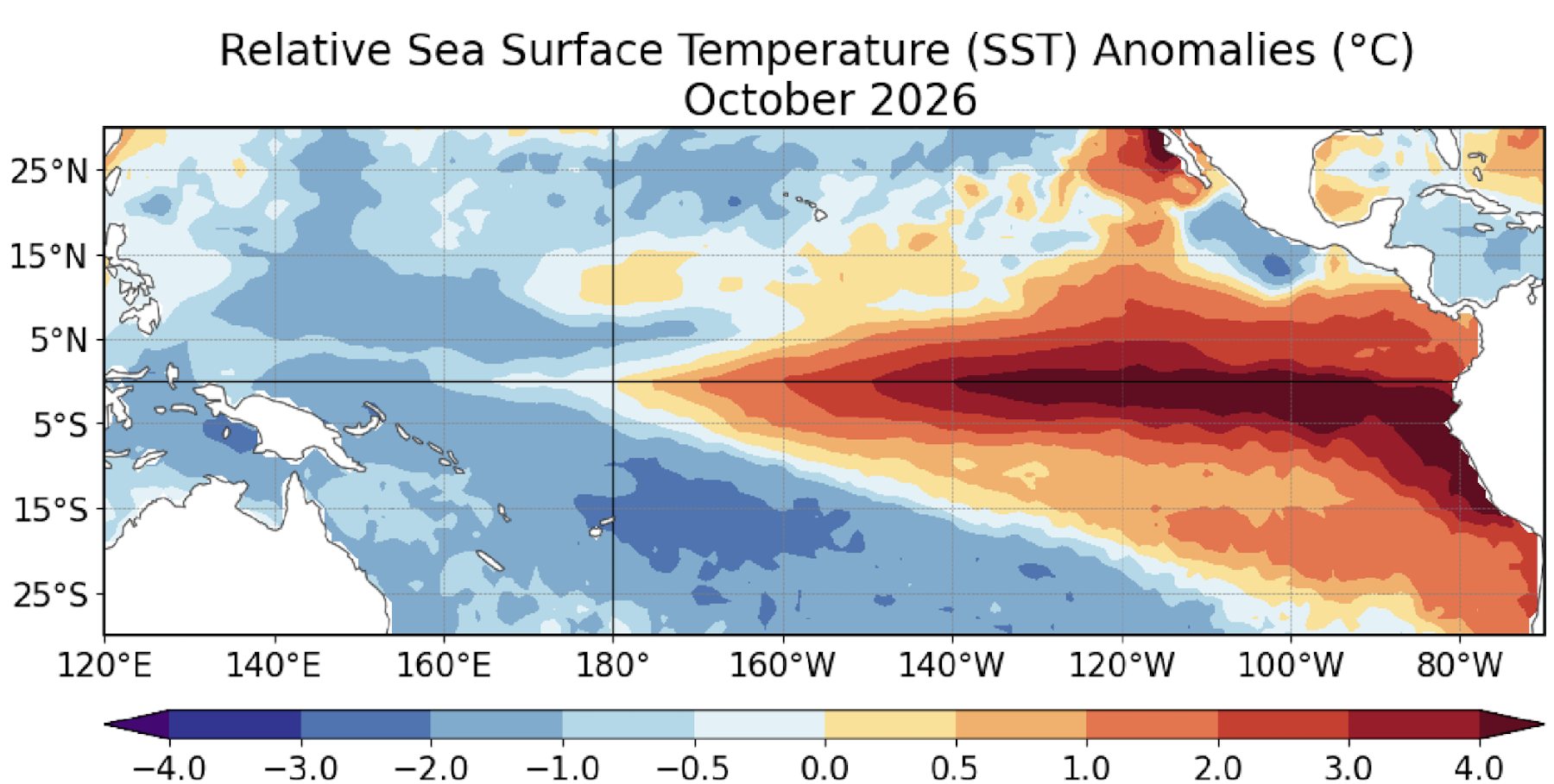
厄尔尼诺是一种自然气候现象,它会提升全球气温并改变世界各地的天气模式。其定义是东中热带太平洋海面温度上升。当该地区温度比平均水平高出至少0.5摄氏度(0.9华氏度)并持续三个月时,全球就处于厄尔尼诺现象之中。8月至10月的平均温度比正常值高出2.5摄氏度(36.5华氏度),这使其成为自1950年以来有记录以来最温暖的时期之一。
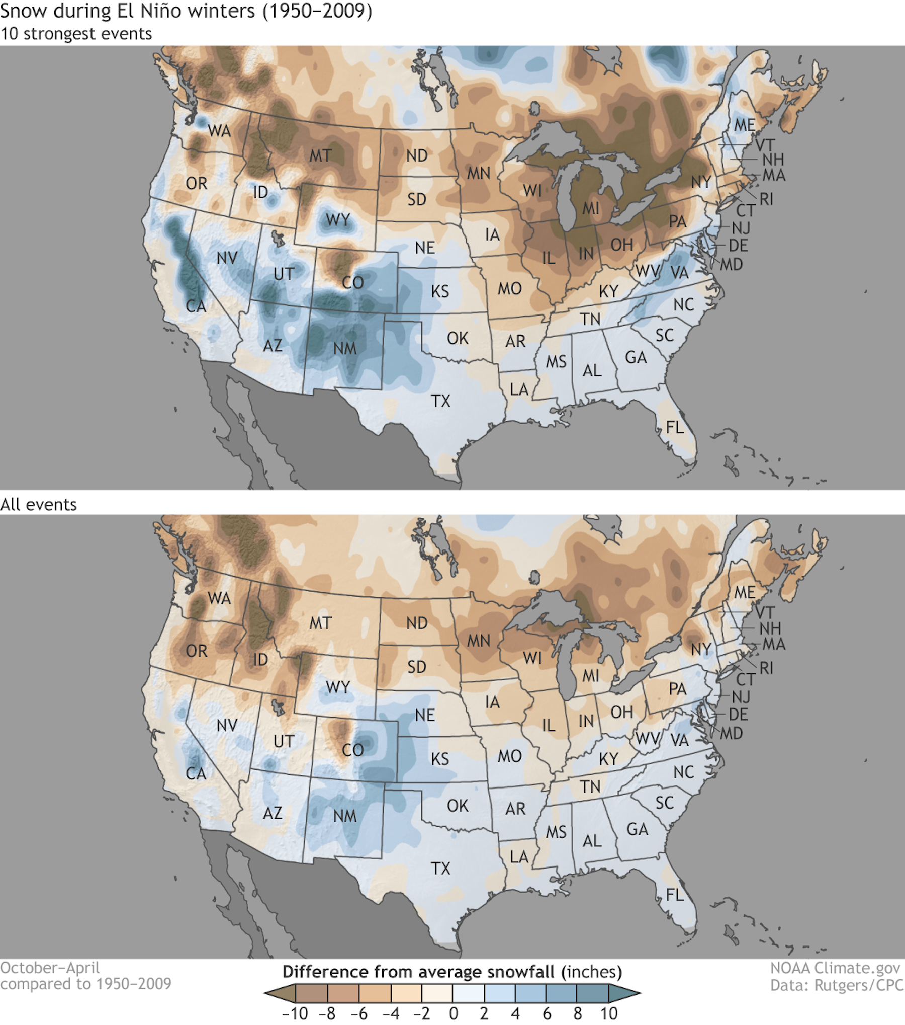
在美国,强厄尔尼诺现象期间,该国南部地区往往比平常更潮湿。这是因为太平洋急流向南移动,带动风暴一同移动。而美国北部地区则往往比正常情况下更干燥、更温暖。
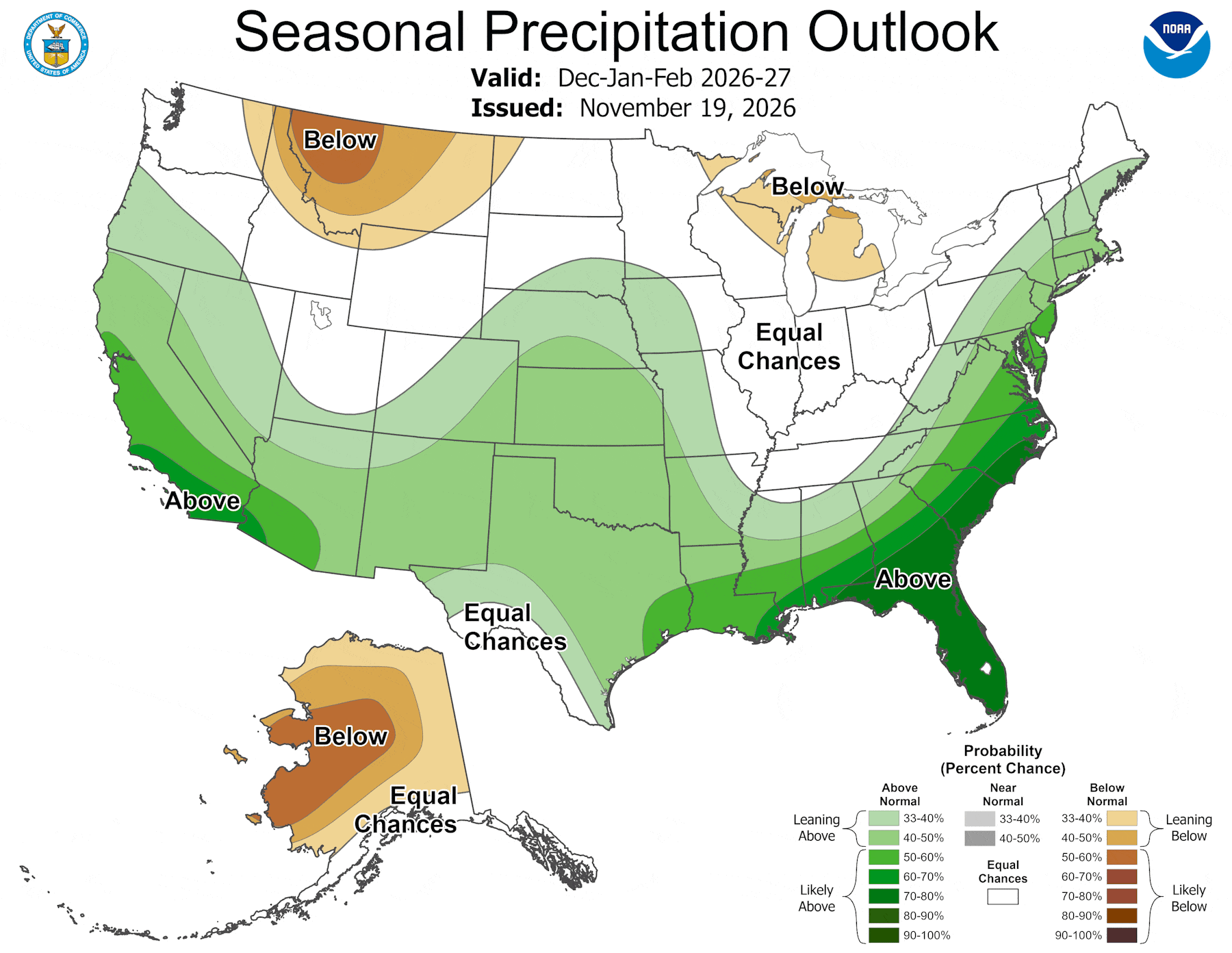
2026-27年的美国冬季几乎就预示着这样的天气模式。美国西南部地区目前也正在经历这种情况,且程度极为严重。10月和11月,厄尔尼诺现象加剧的强风暴在新墨西哥州、亚利桑那州、科罗拉多州和犹他州的“四角地区”引发了大规模的破坏性洪水。快速融化的积雪加上连日的暴雨导致圣胡安河和里奥格兰德河水位上涨,数百栋房屋遭到损毁。
从去年的雪灾中恢复
在去年冬季美国西部几乎整个地区遭遇有记录以来最少的降雪量之后,该地区的社区供水系统及农场亟需降水。科罗拉多河流域的主要水库水位在一年中降到了自最初蓄水以来的最低水平。其中规模最大的两个水库——鲍威尔湖和米德湖——为约4000万人提供饮用水,同时为数十万人提供水力发电。极低的降雪量,再加上异常温暖的仲冬气温促使雪发生升华——即雪的蒸发——导致山区储存的水量减少。随后又出现了创纪录的高温夏季。
2026年秋季的强降雨和降雪或许有助于弥补去年的不足,从而开始缓解已持续25年、给美国西部各地带来供水问题的长期干旱状况。
一个积极的迹象是,最近的降雨使得鲍威尔湖水位上升。总体而言,预计2026-27年将出现超级厄尔尼诺现象,这将在美国南部和中部的大部分地区带来高于平均水平的降雨和降雪,也有望缓解那里的干旱状况。
智利的情况……
像我这样的雪况专家会密切关注这类厄尔尼诺年份中的南美洲冬季情况,因为这能让我们预判北美洲即将面临的状况。请记住,过去几个月里厄尔尼诺现象一直在加剧——这一趋势在刚刚结束的南美洲冬季期间依然存在。
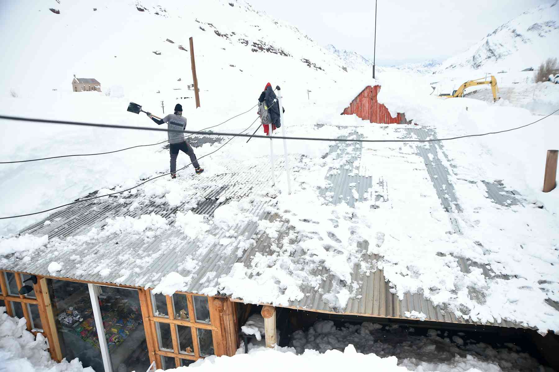
南美洲出现了大量降雪,尤其是在智利中部的安第斯山脉。在波蒂略等一些地区,降雪量是自2010年干旱开始以来的最大值,而在圣地亚哥以北的利马里河上游地区,则是过去70年来降雪量最大的时期。
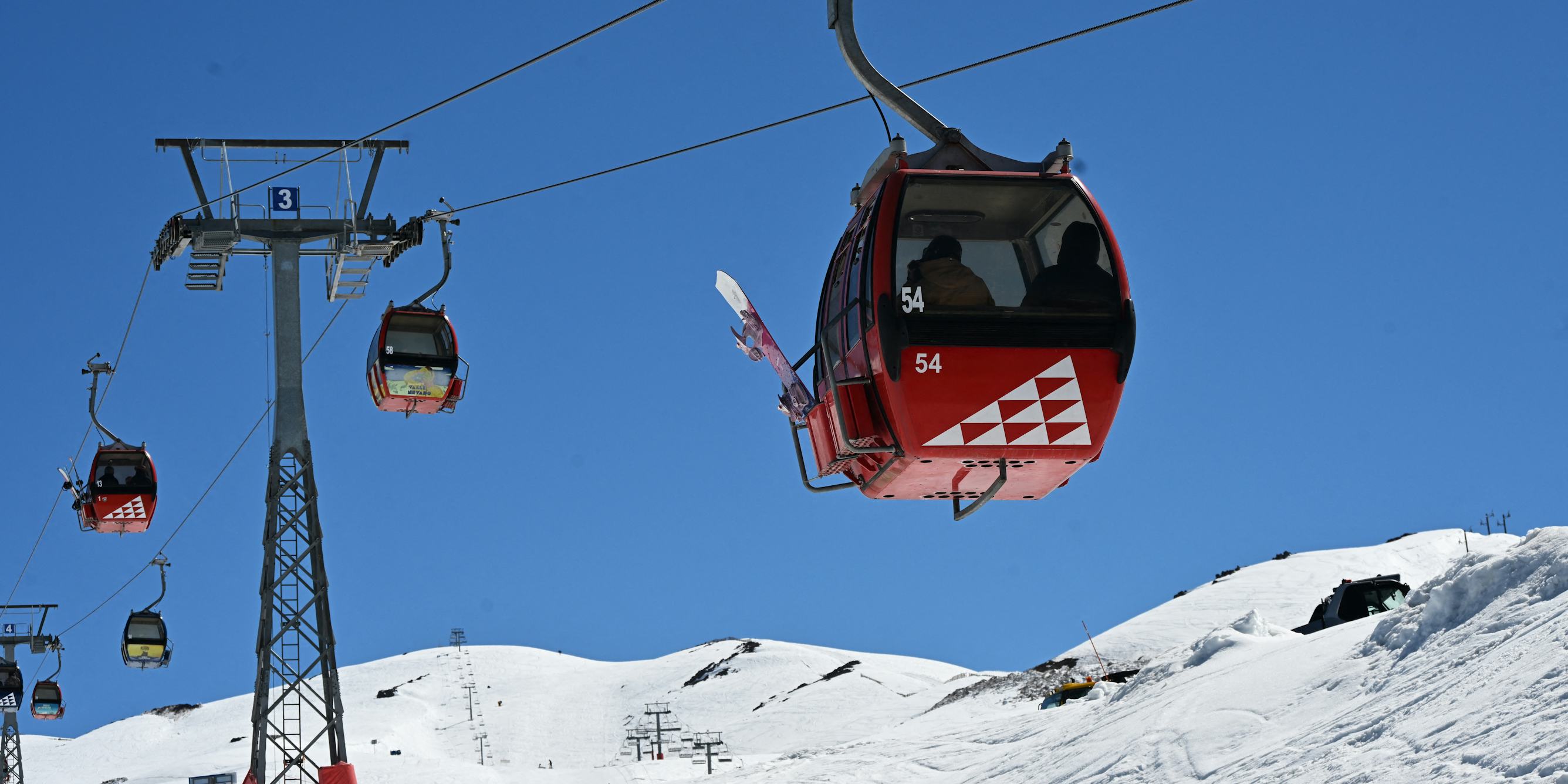
这些降雪对智利的滑雪场来说是个好消息。瓦耶内瓦多滑雪场的积雪深度超过了24英尺(7.3米),这使得原定10月初结束的滑雪季延长到了12月初。就连极度干燥的阿塔卡马沙漠也出现了大范围降雪,随后春季花卉大量绽放。
从历史来看,智利的多雪冬季往往也会导致加利福尼亚州的内华达山脉和南部落基山脉出现降雪。厄尔尼诺现象带来的温暖海洋环境使得该地区的大气比平常能吸收更多水分,进而为美国西南部带来暴风雪。如果今冬仍保持这种趋势,西部地区的中部和南部将会出现远高于平均水平的积雪量以及活跃的滑雪季,而那些严重缺水的水库也将有机会至少部分得到补充。
原文
El Niño has a reputation for being a skier’s dream, bringing lots of snow to California’s Sierra Nevada and the southern Rockies. Tahoe-area resorts were already seeing the effects in mid-November 2026 as several feet of snow fell and some resorts prepared to open early for the season. But El Niño’s supercharged precipitation can spell trouble, too.
I’m an avid skier and snow scientist at Colorado State University. As the U.S. snow season begins amid what’s forecast to be one of the strongest El Niños on record, let’s take a look at what Chile’s very snowy winter might tell North America about what’s to come.
The pros and cons of all that precipitation
El Niño is a natural climate phenomenon that raises global temperatures and shifts weather patterns around the world.
It is defined by rising surface temperatures in the east-central tropical Pacific Ocean. When temperatures there are at least 0.5 degrees Celsius (0.9 Fahrenheit) warmer than average for three months, the world is in El Niño. The August-October average was 2.5 C warmer (36.5 F, making this among the warmest periods on record going back to 1950.
In the U.S., the southern half of the country tends to be wetter than usual during strong El Niños. That happens because the Pacific jet stream shifts southward, steering storms with it. The northern tier of the U.S. tends to be drier and warmer than normal.
That pattern is almost exactly what’s being forecast for the U.S. winter of 2026-27. It’s also what the U.S. Southwest is already experiencing – to the extreme.
Powerful storms supercharged by El Niño in October and November caused widespread destructive flooding in the Four Corners region of New Mexico, Arizona, Colorado and Utah. Fast-melting snow and days of heavy rain flooded the San Juan River and Rio Grande, damaging hundreds of homes.
Recovering from last year’s snow drought
Community water systems and farms across the West need that precipitation after last winter delivered one of the lowest snow years on record for almost the entire western United States.
Major reservoirs in the Colorado River basin dropped during the year to their lowest levels since they were first filled. The two biggest – Lake Powell and Lake Mead – together supply water for about 40 million people and hydropower for hundreds of thousands of people.
The very low snowfall, as well as unusually warm midwinter temperatures that drove sublimation – the evaporation of snow – reduced water stored in the mountains. And that was followed by record-high summer temperatures.
Fall 2026’s heavy rain and snow may help make up for last year and start to alleviate a long-running drought that has been causing water supply problems across the western U.S. for a quarter century.
In a positive sign, Lake Powell rose with the recent rains. Overall, the Super El Niño conditions being forecast for 2026-27 are expected to bring more than average rain and snow this winter across much of the southern and central United States, where it’s also likely to alleviate drought.
What happens in Chile …
Snow scientists like me keep an eye on the South American winter in El Niño years like this because it can give us a sense of what’s coming for North America.
Keep in mind that El Niño has been strengthening over the past few months – including through the South American winter that just ended.
South America saw a huge amount of snow, particularly in the central Chilean Andes. In some areas like Portillo, the snow accumulation was the deepest since the current drought began in 2010, and the deepest in the past 70 years north of Santiago at the top of the Limarí River.
The snow was a boon for Chile’s ski resorts. Valle Nevado got over 24 feet (7.3 meters) of snow and extended its ski season, originally scheduled to end in early October, into early December. Even the extremely dry Atacama Desert saw widespread snow followed by an explosion of spring flowers.
Historically, snowy winters in Chile have meant snowy winters for California’s Sierra Nevada and the southern Rockies, too. The warm El Niño ocean allows the atmosphere to pick up more moisture in this zone than usual, and this brings snowstorms to the U.S. Southwest.
If that pattern holds this winter, the southern and central parts of the West should see well-above-average snowpack and active ski seasons, and those dangerously depleted reservoirs will have a chance to at least partially refill.