社会民生
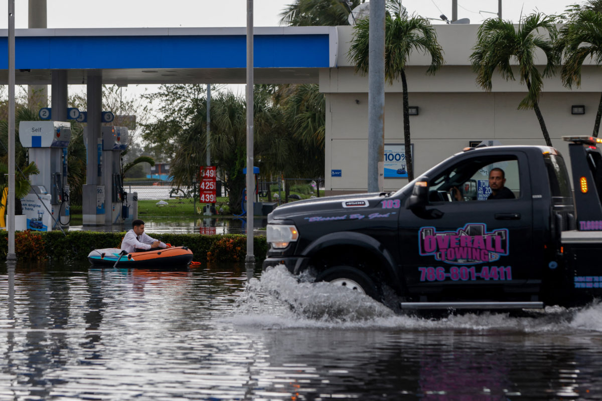
佛罗里达州东北部目前因暴雨而面临洪水威胁,这些暴雨已严重破坏了沿海社区。
中文译文
周五,导致佛罗里达州大西洋沿岸大片地区被水淹没并引发数十起救援行动的强降雨继续向北移动。气象预报员警告称,由于一条主要河流的水位预计将远超历史记录,洪水威胁可能持续到下周。
美国国家气象局发布了洪水警报和警戒信号,覆盖范围从墨尔本以南约200英里(320公里)处一直延伸到杰克逊维尔地区。预计到周六,这些地区还将有2到6英寸(5到15厘米)的降雨,部分地区甚至可能迎来8到10英寸(20到25厘米)的额外降雨量。
视频:超级厄尔尼诺现象如何加剧极端天气
气象局在周五早间的预报中表示:“预计将出现严重且大范围的突发性洪水。此外,通常不会发生突发性洪水的地区也将被淹没。生命和财产面临巨大危险。”佛罗里达州最长的圣约翰斯河在周四靠近科科亚的地区水位上升至1953年创下的纪录水平。气象部门称,预计该河水位至少会在洪水位以上2英尺(61厘米)持续到下周初。
迈阿密的美国国家飓风中心表示,周五还将形成一个非热带低压系统,有可能在美国东南部沿海发展成亚热带或热带风暴。在感恩节假期来临之前,东南部和大西洋中部沿海地区将面临强风、危险的海浪以及沿海洪水。
根据气象部门的初步数据,自周二以来,佛罗里达州东海岸部分地区的降雨量已超过17英寸(43厘米),此外本月早些时候还出现了大量降雨。已有几个地方经历了有记录以来最潮湿的11月。周四,风暴向北移动至佛罗里达的太空海岸地区,导致河流泛滥,人们在本应属于佛罗里达干燥季节的10月至5月间不得不接受水上救援,救助被困的人和马匹。
“在佛罗里达从未见过这样的情况,”贾兹敏·福斯特说,她的梅尔伯勒住所两周内第二次被水淹没。
周四,在布雷瓦德县,一些驾驶拖车的人在齐膝深的水中救援位于可可市的蓝湖马术中心里的数十匹马和其他动物。这些动物随后被转移到其他干燥的牧场。
韦恩·艾维警长表示,急救人员在该县进行了近100次水上救援,而且这一数字还在上升。帕姆贝伊市对某个活动房屋社区的居民实施了强制疏散,同时为那些被迫离开家园的居民设立了避难所。应急管理部称,已有近200名佛罗里达州国民警卫队成员及50辆高水位救援车辆被派往该州沿海地区提供援助。其他参与救援的机构还包括佛罗里达州鱼类及野生动物保护委员会的约235名工作人员。
本周的暴风雨是由弗吉尼亚州上空持续的高压系统以及墨西哥湾的低压系统及相关的静止锋共同作用导致的,这些因素共同推动了风暴持续向佛罗里达半岛岸边移动。这些暴风雨是厄尔尼诺现象的衍生现象,厄尔尼诺是指赤道附近太平洋地区的自然升温现象,会改变全球的天气模式。
气象预报员表示,厄尔尼诺现象预计将持续到春季,这意味着佛罗里达州和加利福尼亚州的极端潮湿天气很可能会持续到冬季。本周,从洛杉矶到旧金山的加利福尼亚海岸多地也遭遇严重洪水,许多社区被水淹没,一些司机不得不弃车于洪水中。由于山体滑坡和泥石流,1号海岸公路在蒙特雷半岛以南的很长一段路段被封闭。
美联社驻加利福尼亚州圣安娜的记者艾米·塔克辛和驻拉斯维加斯的记者杰西卡·希尔为这篇报道提供了素材。
原文
Heavy rains that left large swaths of Florida's Atlantic coast under water and led to dozens of rescues moved further north on Friday as forecasters warned flooding threats could stretch into next week when a major river is expected to crest well above record levels.
The National Weather Service posted flood warnings and watches stretching around 200 miles (320 kilometers) from just south of Melbourne to the Jacksonville area. Additional rainfall of 2 to 6 inches (5 to 15 centimeters) was expected through Saturday, while some areas could see an extra 8 to 10 inches (20 to 25 centimeters).
WATCH: How a super El Niño is fueling extreme weather patterns
"Severe, widespread flash flooding is expected," the weather service said in a Friday morning forecast. "In addition, areas that normally do not experience flash flooding will flood. Furthermore, lives and property (are) in great danger."
The St. Johns River, Florida's longest, rose above a record level Thursday near Cocoa that was set in 1953. The river is forecast to stay at least 2 feet (61 centimeters) above flood stage through early next week, the weather service said.
Also Friday, a nontropical low-pressure system was expected to form and could become a subtropical or tropical storm along the southeastern U.S. coast, the National Hurricane Center in Miami said. The southeast and mid-Atlantic coasts should expect strong winds, dangerous surf and coastal flooding into early next week ahead of the Thanksgiving holiday.
Parts of Florida's east coast have been deluged with rainfall totaling more than 17 inches (43 centimeters) in some spots since Tuesday, according to preliminary totals by the weather service. That's in addition to heavy rains that fell earlier this month. Several places have already seen their wettest November on record.
The storms shifted north to the Space Coast on Thursday, sending rivers over their banks and prompting water rescues of people and horses during what is supposed to be Florida's dry season that runs from October to May.
"Never seen such a thing like this in Florida," said Jazmin Foster, whose Melbourne home was inundated with water for the second time in two weeks.
In Brevard County on Thursday, people with trailers braved knee-deep water to rescue dozens of horses and other animals at the Blue Lake Equestrian Center, an animal hospice and boarding facility in Cocoa. The animals were taken to a dry pasture elsewhere.
First responders conducted nearly 100 high-water rescues across the county, and those numbers continued to climb, Sheriff Wayne Ivey said. The city of Palm Bay conducted mandatory evacuations for some residents of a mobile home community. Shelters were opened for residents forced from their homes.
Nearly 200 Florida National Guard personnel with 50 high-water vehicles have been deployed to help up and down the coast, the Division of Emergency Management said. Other responding agencies included about 235 officers with the Florida Fish and Wildlife Conservation Commission.
This week's storms have been fueled by persistent high pressure over Virginia and a low-pressure system and an associated stationary front in the Gulf, which together have pushed a steady onshore flow across the Florida Peninsula. They're an offshoot of El Niño, the natural warming of the Pacific near the equator that warps weather patterns worldwide.
Forecasters said El Niño conditions are expected to persist through the spring, meaning the soggy extreme weather in Florida and California will likely continue through the winter.
The California coast, from the Los Angeles to San Francisco areas, was also swamped with flooding in many areas this week, leaving neighborhoods under water and forcing some drivers to abandon stalled vehicles in floodwaters. A long stretch of the coastal Highway 1 was closed south of the Monterey Peninsula due to rock and mud slides.
Associated Press writers Amy Taxin in Santa Ana, California, and Jessica Hill in Las Vegas contributed to this report.